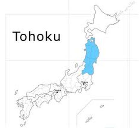
TOHOKUTohoku means “North East,” but when the poet Basho (1655-1694) made his famous journey to the eponymous region at the top of Honsu in 1689, it was just the “deep north.” Mountainous, wild, and often bitterly cold in winter, Tohoku was extremely remote in those days. Some of it still is.
It is well known for its countryside, mountains, lakes, hot springs, high quality rice and rough winters. The Tohoku Region was hit by the earthquake and tsunami of March 11, 2011 and the ensuing nuclear accident. However, most areas of the Tohoku Region are now safe and welcoming tourists again. Of all the destinations in our travel guide, only Sendai, Matsushima, Iwaki and the Sanriku Coast suffered direct damage from the earthquake and tsunami, and even there most attractions reopened within a few weeks or months. Summer in Tohoku is comparatively cool in general. In winter it snows in Tohoku focusing on the Sea of Japan side. The four seasons are very clear. Since the steep high mountains divide Tohoku into east and west, the climate greatly differs between the Pacific Ocean side and the Sea of Japan side. In summer, the temperature seldom goes up very high on the Pacific Ocean side because the cold “yamase” wind blows, and it is relatively cool. On the other hand, on the Sea of Japan side, it is hot mainly on the basin areas. When winter comes on the Pacific Ocean side, fine weather continues and there is little snow fall. On the Sea of Japan side, much snow falls, and especially in the mountainous areas snow falls to about 5 m, which results in a world’s distinguished heavy snowfall area. Since the Tohoku region extends north and south, there is a difference of 4°C in the average temperature between northern and southern Tohoku. Although it is relatively mild in the spring cherry blossom season and the autumn foliage season during the day, it may become considerably cold in the morning and the evening even on flat lands. Moreover, in mountainous areas it is lower by 10°C or so than on flat lands. Be sure to take precautions against the cold. |
|
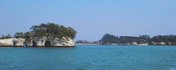
1. Sendai & Matsushima
Tohoku’s largest city, Sendai, is the capital of Miyagi-ken. An important business center, it has a good number of hotels, making it a convenient base for exploring the region. Most of all, visitors use Sendai as a base for visiting nearby Matsushima-wan, which along with Miyajima and Amano-hashidate ( Kyoto-ken), is one of the Three Great Sights of Japan.
The warlord Date Masumune built Aoba-jo Castle in 1602. The castle was ruined long ago, but its foundations still lie in the city park. Other vestiges of the Date legacy were obliterated with most of Sendai during the air raids of World War II. Unlike most resurrected Japanese cities, Sendai breaks the monotony of concrete by lining its boulevards with trees. Along with the usual covered shopping arcades and an exuberant street market, Sendai is home to Kokubuncho, Tohoku’s largest amusement district.
The Date family mausoleum, the 16th-century Memorial Hall (Zuihoden), and ornate Osaki Hachiman-jinja Shrine, built in 1607, miraculously survived the war. Otherwise, despite having a few attractive temples and gardens, Sendai is not known for historical sights. The surrounding hills boast hiking trails and hot springs, as well beautiful scenery in the gorges of Futakuchi and Raira-kyo and especially near the town of Naruko, renowned for the curative properties of its spas. Near Sendai too is the 180-foot (55 m) Akiu Otaki Waterfall, among the country’s most spectacular cascades.
2. Akita-ken
In the northwest of Tohoku, Akita-ken encompasses high mountain ranges in the north, east, and south; 70 percent of the land is forested. The mountains of Akita are renowned for Lakes Towada-ko and Tazawa-ko, for the sylvan Hachimantai Plateau , and for their sheer scenic beauty. Ski resorts abound, and being volcanic, the mountains have plenty of hot springs, notably those in remote resort of Nyuto Onsen. Jutting 12.5miles (20 km) into the Sea of Japan, the Oga-hanto Peninsula, transportation dwindles to a bare minimum in winter. The region’s most interesting town by far is Kakunodate, famed for one of the largest and best-preserved samurai district in the country.
Archaelogical finds have shown that the region was inhabited at least 20,000 years ago, probably by tribes related to the Ainu. The army of the Yamato court took Akita in 658 and drove the Ainu ever further north; Akira city grew out of a permanent garrison established in eighth century. In 1602, the year before he founded the national government that would last for centuries, the shogun Tokugawa lesayu appointed the Satake clan as the first lords of Akita. The Satake later moved to Kakunodate, and until the fall of Shogunate in 1867, rule of the province was shared by families collectively constituting the Akita clan.
Japan’s sixth-largest prefecture, it consists of 13 cities, six counties, nine towns and three villages, most of which are close to – or in – an onsen. People are as warm as the hot-spring water, making Akita a great place to relax before heading northward to Hokkaidō or going back on down south. The Oū Mountain Range and Dewa Mountain Ranges ensure there’s plenty of hiking opportunities.
3.Iwate-ken
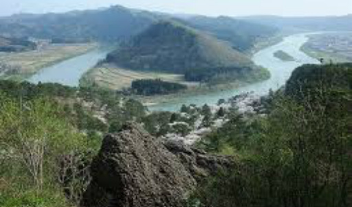
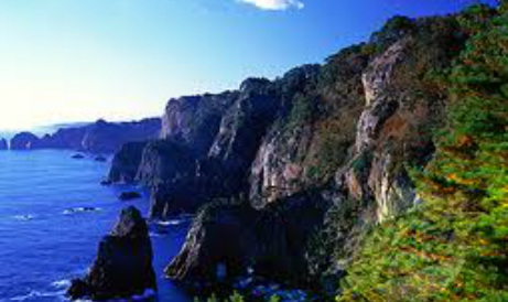
Iwate is one of the largest prefectures in Japan, blessed with fertile land and beautiful nature. There are numerous mountains, the highest being Mt. Iwate, also known as Nambu Fuji or the “Half-Sided Fuji of the Nambu Fief” for its resemblance to Mt. Fuji. Surrounded by the mountains are cities such as the prefectural capital Morioka and various historical sites such as those representing Hiraizumi Culture. In Iwate there are also numerous hot springs and tasteful inns which are perfect for relaxation after long hours of traveling. The coastal area, called Sanriku, is designated as Rikuchu Kaigan National Park. Sanriku boasts a variety of scenic landscapes and is also one of the best fishing grounds in the world, famous for its fresh, wholesome seafood. Cherry blossoms in spring, beach in summer, colorful foliage in fall, skiing and snowboarding in winter---any season of the year is the right time to visit and enjoy Iwate
Iwate's climate varies widely depending on the area. Most of Iwate's inland areas are mountainous, with the Ou Mountains on the western border with Akita prefecture and the Kitakami Highlands in the east. The Kitakami River flows south between these two mountain ranges, with fertile plains spreading around it. The areas along the Ou Mountains are blessed with abundant and excellent snow, and boast some of the best ski resorts in Japan. The inland areas along the Kitakami Highlands have plateau and basin climates, with a large temperature difference between summer and winter, and between night and day. Morioka, the prefectural capital, has many cold days in winter. The coastal areas have a maritime climate: cool in summer, not so much snow and not as cold as the inland areas in winter. Such varying climates contribute to Iwate's stark and vivid contrast of the four seasons.
Iwate's climate varies widely depending on the area. Most of Iwate's inland areas are mountainous, with the Ou Mountains on the western border with Akita prefecture and the Kitakami Highlands in the east. The Kitakami River flows south between these two mountain ranges, with fertile plains spreading around it. The areas along the Ou Mountains are blessed with abundant and excellent snow, and boast some of the best ski resorts in Japan. The inland areas along the Kitakami Highlands have plateau and basin climates, with a large temperature difference between summer and winter, and between night and day. Morioka, the prefectural capital, has many cold days in winter. The coastal areas have a maritime climate: cool in summer, not so much snow and not as cold as the inland areas in winter. Such varying climates contribute to Iwate's stark and vivid contrast of the four seasons.
