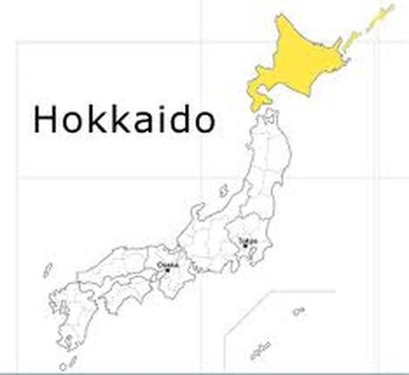
HOKKAIDO
|
|
1. Abashiri & Shiretoko Natonal Park
Abashiri is located at the mouth of the Abashiri-Gawa River on the sea of Okhotsk, a port for the trout and salmon fishing industry. From December to March, when the port closes down as the bay fills with ice floes, it is a lonely place. There are Abashiri Prison Museum which is built on Mount Tento-zan near the city in 1890. Abashiri is also home to the Okhotsk Ryuhyo Museum. With its subzero temperatures and great blocks of ice, it seems designed to show summer visitors what they missed from winter. To see the ice floes on the Sea of Okhotsk in midwinter; come February, the sea is frozen to the horizon, and sightseeing excursions are provided aboard an icebreaker.
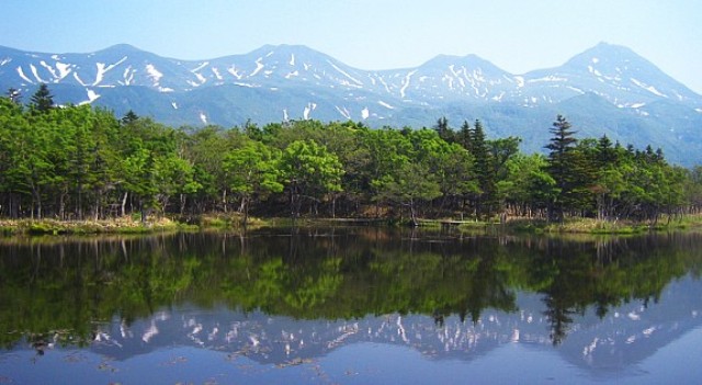
Above all, Abashiri is the gateway to Shiretoko National Park, Japan’s only true wilderness, which was granted UNESCO World Heritage Sites status in 2005. The road runs along the coast to the town of Utoro in the west and connects with the small town of Rausu in the east. Beyond it there are no more roads: Shiretoko is the Ainu word for “world’s end.” Fox, deer, and bear roam the last 25 miles (40 km) of the peninsula. Some 6 miles (10 km) northeast of Utoro is one of the park’s highlights, the beautiful Shiretoko Five Lakes, where wooden walkways encircle bodies of water in virgin forest crisscrossed by hiking paths. Another 6 miles (10 km) farther on is Kamuiwakka-no-taki, an onsen area characterized by a warm-water river offering the novel experience of bathing in cascades and waterfalls of hot water. Of the many walks within Shiretoko park, the most popular is the ascent of Rausu-dake, the highest peak in the volcanic range at the park’s center. Allow up to five hours for the climb. From the peak you can walk north to lo-zan, the volcano that heats the water at Kamuiwakka-no-taki; the trek to the peak and back takes around eight hours.
Above all, Abashiri is the gateway to Shiretoko National Park, Japan’s only true wilderness, which was granted UNESCO World Heritage Sites status in 2005. The road runs along the coast to the town of Utoro in the west and connects with the small town of Rausu in the east. Beyond it there are no more roads: Shiretoko is the Ainu word for “world’s end.” Fox, deer, and bear roam the last 25 miles (40 km) of the peninsula. Some 6 miles (10 km) northeast of Utoro is one of the park’s highlights, the beautiful Shiretoko Five Lakes, where wooden walkways encircle bodies of water in virgin forest crisscrossed by hiking paths. Another 6 miles (10 km) farther on is Kamuiwakka-no-taki, an onsen area characterized by a warm-water river offering the novel experience of bathing in cascades and waterfalls of hot water. Of the many walks within Shiretoko park, the most popular is the ascent of Rausu-dake, the highest peak in the volcanic range at the park’s center. Allow up to five hours for the climb. From the peak you can walk north to lo-zan, the volcano that heats the water at Kamuiwakka-no-taki; the trek to the peak and back takes around eight hours.
2. Rishiri-Rebun-Sarobetsu National Park
Up in the far northwest of Japan, this national park comprises the beautiful and hiker-friendly islands of Rishiri and Rebun; on the mainland opposite is the Sarobetsu Plain, a strip of coastal swampland some 21 miles (34 km) long. Just the north of the Sarobetsu Plain, the remote coastal town of Wakkanai has a reputation for bleakness. Many Japanese come here just to see the view over the disputed island of Sakhalin to the north, then go on to nearby Cape Soya-misaki.
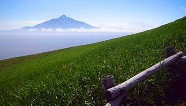
The rounded island of Rishiri-to is crowned by a conical volcano often compared to Fuji-san, the magnificent 5,646-foot (1,721 m) Rishiri-zan. This is the island’s main draw; there are several trails to the summit, including one for serious climbers. None of the routes is especially easy. To ascend and descend Rishiri-zan takes about ten hours, but there are less strenuous walks through lower, greener hills dotted with alpine flowers, notably to the scenic Hime-numa Pond. The visitor information centre at the island ferry terminal in Oshidomari has maps and guides describing the various trails in English.
Rebun-to, a narrow, wedge shaped isle some 9 miles (15km) long, is smaller than Rishiri but more interesting. Famous for carpets of hundreds of varieties of alpine flowers in summer, its rolling hills culminate in the 1,607-foot (490m) Rebun-dake. The most popular hiking routes on Rebun run along the west coast, taking in cliffs, remote fishing hamlets, and a striking array of both wooded and marine scenery.
There are two main ports, Kafuka in the south and smaller Funodomari in the north; both offer a range of accommodations, as do the villages of Motochi in the southwest and Shiretoko on the southern tip.
The Sarobetsu Genya Plain, the remaining area of the park, is famous for its colorful summer flowers, especially irises, lilies, and rhododendrons.

3. Daisetsuzan National Park & central Hokkaido
Right in the centre of Hokkaido and in every way the island’s heart. Daisetsuzan National Park covers some 890 square miles (2,300 sq km), making it Japan’s largest national park. Its backbone is a mountain range known as the “roof of Hokkaido,” culminating in the 7,513-foot-high (2,290m) Mount Asahi-dake, the island’s highest peak. The park and its mountains are famed for beautiful valleys, steep cliffs, and spectacular waterfalls, in addition to the hot springs sprinkled about the foothills. Most notable is Sounkyo spa in the north of the park, which is also the main staging point for a variety of mountain walks in the region.
One excellent area for hiking is the 15-mile (24 km) Sounkyo Gorge, with its rich tapestry of color in the fall and lovely waterfalls, some of which cascade 500 feet (150 m) down a sheer drop, in particular over the Obako and Kobako cliffs. South of Asahi-sake is the park’s other great gorge, Tennin-kyo, again with waterfalls in beautiful sylvan settings, as well as a number of hot springs.
Twenty five miles (40km) northwest of Daisetsuzan National Park is Asahikawa, Hokkaido’s second largest city. Though of little interest to travelers, it is an important transportation hub; many people therefore opt to stay here out of sheer convenience. Some use it as a gateway to the park if they plan to visit on a day trip, but this is not a truly satisfactory option: You would be better off staying in the park itself, especially in a scenic area such as that around Sounkyo Gorge.
About 30 miles (50 km) southwest of Asahikawa is Furano, an area important for its winter sports, scenery, and agriculture. Furano resort has some of the best snow conditions in Japan, and it often hosts international ski events. A major producer of grapes, potatoes, beans, asparagus, and other vegetables, the area around the Tokaichi foothills has become popular among Japanese tourists for its vast fields of lavender.
